
Why in News: The 1950 Great Assam Earthquake, the strongest recorded on land (magnitude 8.6), serves as a reminder that the Eastern Himalayas remain highly seismically active.
Overview
Date: August 15, 1950 (India’s Independence Day)
Magnitude: 8.6 — strongest earthquake ever recorded on land.
Duration of shaking: 4–8 minutes.
Affected Area: ~3 million sq. km across India, Tibet, Myanmar, Bangladesh, and South China.
Casualties:
- India: ~1,500 dead, 50,000–100,000 cattle lost.
- Tibet (Medog area): over 4,000 dead.
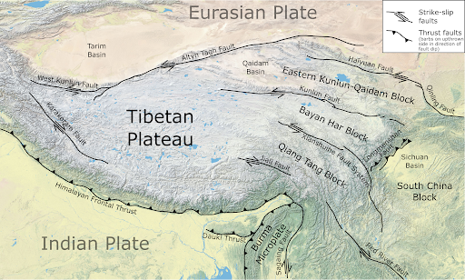
Tectonic Setting and Cause
- Epicentre: ~40 km west of Rima (Zayu), near the India–Tibet border in the Mishmi Hills.
- Depth: ~15 km.
Plate Tectonics:
- Located near the Eastern Himalayan Syntaxis (EHS) — a tectonically complex region.
- Indian Plate colliding with Eurasian Plate; Sunda Plate also involved.
- Plate convergence: 10–38 mm/year in Eastern Himalayas vs. ~20 mm/year average across Himalayas.
Fault Mechanics:
- Different from typical Himalayan thrust earthquakes.
- Displayed strike-slip motion with a thrusting component.
- Likely involved multiple linked faults, starting in the Syntaxial bend and propagating west.
Scientific Significance
- Provided data that strengthened the emerging plate tectonics theory.
- First major Himalayan quake to be instrumentally monitored in India (IMD established first observatory in 1898, Alipore
Modern Implications of the 1950 Great Assam Earthquake
1. Seismic Risk – Northeast India and Eastern Himalayas remain highly active; a similar 1950-type quake is possible.
2. Urban Vulnerability – Rapid urbanisation increases human and economic exposure.
3. Infrastructure Risks – Large projects (dams, hydroelectric plants) in fragile zones face high seismic threats.
4. Disaster Preparedness – Need for stronger early warning systems, monitoring, and emergency planning.
5. Environmental Concerns – Earthquakes can trigger landslides, flash floods, and river blockages.
6. Policy Measures – Strict building codes, seismic-resistant infrastructure, and public awareness campaigns are essential.
7. Regional Coordination – Transboundary risk management needed due to shared Himalayan seismic zones.
Way Forward for India
1. Seismic Monitoring: Expand and modernize networks; use GPS and satellite data for real-time tracking.
2. Earthquake-Resistant Infrastructure: Enforce building codes; retrofit critical structures and dams.
3. Disaster Preparedness: Develop emergency plans, conduct drills, and raise community awareness.
4. Risk Mapping & Planning: Update seismic hazard maps; guide urban development and infrastructure placement.
5. Secondary Hazard Mitigation: Manage landslide- and flood-prone areas; strengthen river embankments.
6. Regional Cooperation: Share seismic data and collaborate on disaster management with neighboring countries.
7. Sustainable Development: Avoid high-risk zones for critical projects; balance growth with safety.
UPSC Relevance:
1. Geography (GS-1): Tectonics, Himalaya, Seismic zones, Plate movements, Earthquake-prone areas.
2. Disaster Management (GS-3): Earthquake preparedness, early warning systems, infrastructure resilience, hydroelectric projects in seismic zones.
Mains Practice Questions:
Q1. Discuss the lessons from the 1950 Assam Earthquake and their implications for earthquake preparedness in the Eastern Himalayas.