UPSC Mains
GS Paper I
Geography
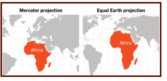
Mercator vs Equal Earth: Why the World Needs a Fairer Map
UNGA backs the 2018 Equal Earth map over the 16th-century Mercator projection — 164 nations in favour, including India, the US against, renewing a debate over cartographic fairness
Resolution Vote
164 in favour, 1 against
Africa vs Greenland
~14x size distortion
Equal Earth Developed
2018, int’l cartographers
📰
Why in News
- The UNGA has supported moving from the Mercator map to the 2018 Equal Earth map, which shows relative country size more accurately. Led by Togo, backed by 164 countries including India; the US voted against and six abstained.
- Though non-binding, the resolution has renewed debate over how maps distort the size and importance of different regions.
Background: Why No Flat Map Can Be Perfect
- Transferring a curved 3D surface onto a flat sheet is called projection — mathematically impossible without distortion in area, shape, distance or direction.
| Projection Type | Preserves | Best Suited For |
|---|---|---|
| Conformal | Angles/local shapes | Navigation (Mercator) |
| Equal-area | True relative size | Thematic maps (Equal Earth) |
| Equidistant | Distance from a point | Flight planning |
| Compromise | Balances distortions | General reference (Robinson) |
The “best” projection is not universal — it depends entirely on the map’s purpose.
🧭
Mercator, Equal Earth, and the Colonial Critique
The Mercator Projection
- Introduced 1569 by Gerardus Mercator — a conformal, cylindrical projection where a straight line represents a constant compass bearing, revolutionary for navigation.
- To preserve angles, it stretches latitude spacing away from the equator — polar landmasses appear far larger, equatorial regions visually shrunk.
The Colonial Critique
- Because colonial powers sat in the Northern Hemisphere’s higher latitudes, critics call Mercator’s inflation of Europe/North America a form of “cartographic hegemony.” The Equal Earth push is framed as a step toward decolonising visual representation.
The Equal Earth Projection
- An equal-area map preserving true relative landmass size, sacrificing some shape accuracy; curved meridians reduce Mercator’s polar stretching.
- Not the first attempt — preceded by Gall (1855), Gall-Peters (1973), Robinson (1963), and Winkel Tripel (1921, adopted 1998 by National Geographic).
Exam trap: Equal Earth is not “perfect” — it merely shifts the trade-off from area distortion to shape distortion, and critics say its achievement may be renewed attention rather than a cartographic breakthrough.
🧭
Way Forward
Purpose-specific adoption
Use Mercator for navigation, Equal Earth or similar for demographic/thematic representation — not a blanket replacement.
Curriculum reform
Introduce multiple projections in school geography to build awareness of distortion and bias in cartography.
Institutional signalling
Bodies like National Geographic Society can standardise equal-area maps for statistical/educational use, as with Winkel Tripel.
Continued advocacy
Since non-binding, sustained Global South advocacy is needed to convert symbolic adoption into institutional change.
Conclusion: Maps are never neutral — they are technical tools shaped by historical purpose that can carry unintended ideological weight. For India and the Global South, the Equal Earth debate is as much about representation and perception as cartographic science.
📰
Source: Indian Express