PRELIMS
NaVIC (Navigation with Indian Constellation)
Why in News: ISRO plans to launch three new satellites before 2026 to replenish ageing and defunct NavIC (Indian Regional Navigation Satellite System) satellites, but progress is slowed due to delays in developing indigenous rubidium atomic clocks, which are critical for accurate navigation.
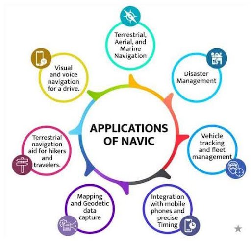
What is NaVIC?
- Navigation with Indian Constellation (formerly IRNSS – Indian Regional Navigation Satellite System).
- Provides accurate positioning, navigation, and timing (PNT) services.
- Coverage: India and a region extending 1,500 km beyond its borders.
- Similar to GPS (USA), GLONASS (Russia), BeiDou (China), Galileo (EU).
Constitution of NaVIC
- Planned: 7 satellites (3 in geostationary orbit + 4 in inclined geosynchronous orbit).
- Till date: 9 satellites launched since 2013; last was IRNSS-1I in 2018.
- Current status: Only 2 satellites have fully functional atomic clocks; 5 satellites are defunct.
Importance
- Provides military (more precise) and civilian (slightly less precise) navigation.
- Acts as a strategic fallback if India is denied access to foreign GNSS during conflicts.
Atomic Clocks in NaVIC
- Provide precise timekeeping, essential for accurate positioning.
- Initially imported from SpectraTime (Swiss firm).
- Problem: Clock failures crippled 5 satellites; some have partial failures.
- New Plan: ISRO to deploy indigenously developed rubidium atomic clocks (5 per satellite).
Recent Developments
- To replenish ageing fleet, 3 new satellites planned before end-2026.
- Replacement satellites: NVS-01 (May 2023) – successfully operational;
- NVS-02 (Jan 2025) – failed to reach proper orbit.
- Procurement challenges: Though indigenous design exists, some critical components are still imported, causing delays.
CEREBO – Handheld Brain Diagnostic Device (ICMR)
Why in News: ICMR has launched CEREBO, a handheld, non-invasive diagnostic device to detect traumatic brain injuries like intracranial bleeding and edema within a minute. It is portable, radiation-free, cost-effective, validated under the mPRiDE scheme.

Developer
ICMR – Medical Device & Diagnostics Mission Secretariat (MDMS)
With AIIMS Bhopal, NIMHANS Bengaluru, Bioscan Research
Technology
- Near-Infrared Spectroscopy (NIRS) + Machine Learning
- Non-invasive, radiation-free, portable, cost-effective
Purpose / Use
- Rapid TBI screening: detects intracranial bleeding & edema in ~1 minute
- Targeted for ambulances, trauma centres, rural clinics, disaster response units
- Safe for infants and pregnant women
- Operable after ~30 minutes training (paramedics/unskilled staff)
Why Needed
- India: >1 million serious head injuries/year; ~1 lakh deaths/year
- 50% of deaths within 2 hours → need ultra-early detection
- Glasgow Coma Scale is subjective; CT/MRI are costly/infrastructure-heavy
Testing, Validation & Feasibility
- Multicentre clinical performance evaluation and utility trials
- Regulatory approvals obtained; demonstrated diagnostic accuracy and faster time-to-decision
- Proven integration feasibility in emergency care pathways
Scheme
- Trials supported under mPRiDE scheme of ICMR–MDMS
- Objective: fund/coordinate multicentre evaluations to generate robust prospective evidence for indigenous medical devices, enabling faster adoption in clinical workflows
Significance
- Helps prevent secondary brain injury (hours–days after impact)
- Reduces mortality, disability, and costs in emergency settings
- Potential for global adoption (emergency & military healthcare)
Hyperloop Mobility System
Why in News: Maharashtra has signed an MoU with IIT Madras startup TuTr Hyperloop Pvt. Ltd. to develop a Linear Induction Motor (LIM)-based hyperloop system, connecting Jawaharlal Nehru Port Trust (Navi Mumbai) with the upcoming Vadhavan Port (Palghar district).
Latest Development
- Maharashtra govt signed MoU with IIT Madras startup TuTr Hyperloop Pvt. Ltd.
- To build a Linear Induction Motor (LIM)-based hyperloop system.
- Route: Jawaharlal Nehru Port Trust (Navi Mumbai) → Vadhavan Port (Palghar district).
About Hyperloop
- Proposed in 2013 by Elon Musk (SpaceX CEO); open source concept.
- Ultra-High-Speed Rail (UHSR) using magnetic levitation (maglev) in near-vacuum tubes.
- Theoretical speed: ~1,200 km/h.

Functioning & Key Components
- A sealed low-pressure tube (~100 Pa) reduces air resistance.
- Pods/capsules travel using Linear Induction Motors (LIM).
- Components: steel tubes, pressurised capsules, compressors for airflow, air bearing suspension.
Advantages
- Ultra-high speed travel (e.g., Mumbai–Pune in ~25 mins).
- Energy efficient; potentially carbon-neutral.
- Noise reduction compared to conventional transport.
- Logistics revolution – faster cargo movement.
Challenges / Issues
- Still conceptual, not commercially proven.
- High costs: ~$25–27 million per mile.
- Safety concerns: fire risk, difficult evacuation inside vacuum tubes.
- Vacuum maintenance challenges.
- Requires straight-line infrastructure and new regulatory frameworks.
Way Forward
Needs substantial funding, sustained R&D, and supportive regulations to overcome technical & safety barriers.
Drake Passage
Why in News: A 7.5 magnitude earthquake struck the Drake Passage, near Argentina and Chile.

Location
- Between Cape Horn (southernmost tip of South America) and the South Shetland Islands (north of Antarctic Peninsula).
Name
- Named after Sir Francis Drake, English navigator and first English circumnavigator of the globe.
Ocean Current
- Major water flow is west to east.
- Forms part of the Antarctic Circumpolar Current – world’s most voluminous ocean current.
Historic Importance
- Served as a key trade route between Atlantic and Pacific Oceans before the opening of the Panama Canal (1914).
Navigation & Sailing
- Known for stormy seas, strong winds, icy waters.
- Cape Horn rounding considered one of the toughest tests for ships and sailors.
Svalbard – Places in News
Why in News: In summer 2024, Svalbard’s glaciers lost nearly 1% of their total ice in just six weeks, triggered by record Arctic heat and warm, moist air — an unprecedented melt event raising concerns about faster sea-level rise.
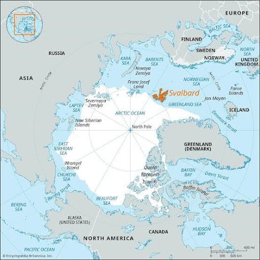
Location
- An archipelago in the Arctic Ocean, north of mainland Norway.
- Lies roughly midway between Norway and the North Pole.
Neighbouring Seas
- Barents Sea (to the east).
- Greenland Sea (to the west).
- Arctic Ocean (to the north).
- Norwegian Sea (to the south, across the Barents Sea).
Geopolitical Significance
- Governed by Norway under the Svalbard Treaty (1920).
- Treaty allows signatory nations equal rights to exploit natural resources.
- Strategic position along Arctic shipping routes (Northern Sea Route).
Environmental Importance
- Covered mostly by glaciers and permafrost.
- Known for polar bears, reindeer, seabird colonies.
- Svalbard Global Seed Vault located here – world’s backup seed storage.
- Identified as a climate change hotspot – warming here is 4–7 times the global average.